

1. GENERAL
Subject to the requirements in a Purchase Order and unless agreed otherwise by the Parties therein or the Agreement, the following information and instructions apply in general in connection with the provision of all Services under the Agreement.
2. SERVICES
2.1. Data Acquisition Services
During an Operation the Pilot shall collect Aerial Data subject to the following Services:
RGB Flights:
The Pilot will cover an area and/or building by taking pictures at regular intervals, with a standard RGB camera according to the equipment list approved by SIDEREAL;
All technical parameters of the Flight(s) will be communicated in the Purchase Order;
The Pilot shall conduct the Flight in accordance with the Flight instructions;
The Pilot shall, at the end of the Flight, deliver all the pictures taken on-site to SIDEREAL in accordance with this Documentations.
Oblique Flights:
In case of taking images of light surfaces the Pilot shall avoid flying during bright sunlight, ideally flights should be performed on cloudy/overcast days;
The Pilot shall fly the entire block without any breaks (change of batteries only);
The Pilot shall ensure oblique images match well with nadir images;
The Pilot shall select the Point of Interest in GSPro or perform the flight manually;
The Pilot shall perform three (3) sets of image capturing:
First flight
In order to ensure suitable overlap with nadir imagery, the Pilot shall capture the first line of oblique photos at the same altitude as the nadir flight;
The camera will be angled at 45 degrees
The Pilot shall fly parallel and along the perimeter of the structure of interest as this will ensure sufficient overlap between nadir and oblique images;
Second flight
The Pilot shall fly parallel to the surface at the altitude set at 60% of the nadir flight;
The camera shall be angled between -20 and -25 degrees, with minimal amount of sky captured;
Third flight
The Pilot shall fly parallel to the surface at the altitude set at 30% of the nadir images
The camera shall be angled at -45degrees
Thermal Flights:
The Pilot will cover an area and/or building by taking pictures at regular intervals, with a thermal camera according to the equipment list approved by SIDEREAL;
All technical parameters of the Flight(s) will be communicated after the Operation has been assigned;
The Pilot shall measure the weather data, including but not limited to (i) irradiance; (ii) temperature; and/or (iii) wind speed, according to the instructions given by SIDEREAL;
Thermal Flights are performed only under the proper irradiance and temperature conditions as communicated by SIDEREAL;
Breaks during successive Thermal Flights will not exceed ten (30) minutes or the time required by any external factor impacting the irradiance (temporary cloud cover, etc.);
The Pilot shall, at the end of the Flight, deliver all the pictures taken on-site to SIDEREAL in accordance with this Documentation.
Multispectral Flights:
The Pilot will cover an area by taking pictures at regular intervals, with a standard camera according to the equipment list approved by SIDEREAL;
All technical parameters of the flight(s) will be communicated in the Purchase Order
The Pilot shall conduct the Operation in accordance with the flight instructions;
5 GCP’s must be placed before Flight in accordance with the instruction in this Documentations;
The propellers must be in the low position in order to not affect the readings from the light sensor;
The Flight shall take place in case of a clear sky. If the sky has partial cloud cover the Flight shall not take place. If there is total cloud cover the pilot can fly if confirmed by the SIDEREAL Operations Coordinator;
The Pilot will take 3 calibration photos before every take off and 3 when landing including battery swaps;
Turn off the camera by pressing the shutter button for 3 seconds before turning off the Drone (not doing so can corrupt the SD Card as the camera is constantly writing a log file on it);
Ground Control Points (GCP) Measurement:
a) In case the Pilot will place and measure the Ground Control Points:
The Pilot shall ensure ther GCPs are surveyed using survey grade instrumentation;
The Pilot shall mark points on the ground and measure their position with an accurate GPS according to technical parameters communicated by SIDEREAL;
The points shall be at the minimum 50cm*50cm in size in order to be visible in the images taken;
GCPs should not be placed in close proximity to high structures or under the canopy of vegetation (trees) as this will impact upon the recording of the GCP position.
The Pilot shall ensure that the GCPs are visible in the images taken
The Pilot shall leave these marks on the ground while flying (either in RGB or Thermal Flights, or both) to have the marks appear on the pictures;
The number of points to be measured will be communicated after the assignment of any Operation requiring GCP Measurement;
GCP accuracy (if applicable) shall be according to the technical parameters communicated by SIDEREAL;
GCP markers (if applicable): use physical markers whose shape, size, color, pattern and material have been approved by SIDEREAL in writing prior to the Operation;
In general, 5 GCP markers must be placed before takeoff. One in each corner and one in the middle;
The Pilot shall, at the end of the Operation, deliver the coordinates measurements of the GCPs to SIDEREAL.
b) In case the Ground Control Points will be placed and measured by a 3rd Party:
The Pilot shall conduct the Flight after the 3rd Party has placed the GCP markers;
The Pilot shall ensure the GCP marks are present at the time of Flying;
The Pilot shall verify the markers are clearly visible in the images taken.
3. DELIVERABLES
3.1. Aerial Data
The Aerial Data collected on Site shall be provided to SIDEREAL at the end of each single Operation and uploaded by Pilot to the SIDEREAL Platform in accordance with its Documentations. In cases where the Operation will take several days the Pilot shall provide to SIDEREAL the Aerial Data collected at the end of each day of flying by uploading the Aerial Data to the SIDEREAL Platform in accordance with its Documentations.
3.2. Flight Logs (if applicable)
The Flight Log shall be completed and signed by the Pilot for each Operation and provided to SIDEREAL at the end of each Operation. In case the Operation takes more than one (1) day the Pilot shall complete one (1) Flight Log per day flown.
When the flight log is required, the pilot will be notified prior to the mission.
4. REQUIRED PILOT DOCUMENTS
At the time of onboarding to SIDEREAL Pilot Network the Pilot shall provide SIDEREAL with the following documents:
Copy of the ID card, passport or a similar document;
Valid Pilot license;
Valid Drone registration for each Drone used for Operations performed for SIDEREAL (if applicable per local regulation);
Valid insurance certificate;
Curriculum Vitae and references.
Upon the renewal of a document the Pilot shall send to SIDEREAL the renewed, valid document.
5. EQUIPMENT REQUIREMENTS
5.1. General Requirements
Make sure that the Drone and associated equipment have the latest firmware available;
Make sure all the equipment (IMU, compass, etc.) have been properly calibrated, maximum one (1) day before each Operation;
The actual accessory used for the flights must be in agreement with the information that the Pilot has communicated at the time of planning the Operation.
5.2. Equipment requirements
For the list of compatible equipment please see the What drone hardware is compatible with SIDEREAL? support article.
6. SIDEREAL PLATFORM
6.1. General Description
SIDEREAL Platform is available under www.app.SIDEREAL.com;
The Pilot shall use the SIDEREAL Platform to upload the collected Aerial Data;
SIDEREAL markets several predefined Data Products which are available to Customer on the SIDEREAL Platform which enables the Customer market relevant business decisions by presenting analytic data and reports;
Customer can order an Operation on the SIDEREAL Platform, by selecting the Site boundaries and choosing a Data Product.
6.2. Data Products
For the list of SIDEREAL Data Products and their flight requirements please see the SIDEREAL Data Products support articles listed below.
6.3. Pilot Access
Upon being onboarded to “SIDEREAL Pilot Network”, SIDEREAL will create the Pilot account on SIDEREAL Platform (www.app.SIDEREAL.com);
The Pilot will receive the login information once the account has been created;
The Pilot shall add the Drone and accessory used in the equipment list on the SIDEREAL Platform.
7. INVITATION TO AN OPERATION
7.1. Invitation
Once Customer orders an Operation on the SIDEREAL Platform, SIDEREAL will send to one or more of its Pilots within the SIDEREAL Pilot Network an automatically generated invitation (hereinafter: the “Invitation”) to perform the Operation. The Invitation is sent to the selected Pilots that entered into a Drone Service Agreement with SIDEREAL according to their office location, availability and equipment. The decision to send the Invitation or not to the Pilot and in what order is at SIDEREAL’s sole discretion and SIDEREAL will not have to justify its decision.
7.2. Information
An Invitation contains the following information:
Customer details;
Description of the Project;
The Site details, including location of the Site(s) where the Operation shall take place;
The Site boundaries within which the flight shall be conducted;
The Data Product chosen by and to be delivered to the Customer, together with the Deliverables;
The duration of the project applicable to the Purchase Order;
The proposed Service Fee and any other compensation in consideration for the Operation performed by a Pilot;
Any other requirements and essential information.
7.3. Assignment
The Operation shall be assigned by SIDEREAL to one of the Pilots to whom an Invitation was sent, such based on a ‘first come first serve’ basis: the first Pilot to confirm its agreement with the terms of the Operation, shall be granted the Operation. SIDEREAL shall send a confirmation of the Invitation of the Operation to the Pilot after the Pilot accepts the Invitation.
7.4. Purchase Order
Following the acceptance by Pilot with the terms of the Operation and confirmation by SIDEREAL, Parties shall execute accordingly a Purchase Order.
8. INTERVIEW, TRAINING AND CERTIFICATION
In order to become a certified SIDEREAL Pilot, each Pilot shall pass the SIDEREAL vetting and training process. As part of the vetting process the Pilot shall provide SIDEREAL with the documents as listed in the Section (Required Pilot Documents). Upon the acceptance of the documentation an interview will be conducted. Upon
passing the interview, SIDEREAL will organize a training on the SIDEREAL operation process and SIDEREAL Platform. The Pilot will be requested to perform a Test flight in order to verify the training efficiency and hardware performance.
9. QUALITY REQUIREMENTS
9.1. Aerial Data
All images shall be in-focus;
No missing or corrupted pictures;
The pictures shall be taken with the highest resolution available for the Drone used;
No motion blur, thus adapting the shutter speed to match the flight speed;
Overlap ratios, both in the front and side directions are in line with the instructions;
JPG with minimal to no compression for RGB pictures.
9.2. Irradiance Level
The Pilot shall ensure that all acquired Aerial Data is capture considering a minimum quality of irradiance level of 600 w/m2;
Irradiance measurement (if applicable): measured in two ways, before each take off:
Pointing directly at the sun (max value);
Parallel to the solar panels;
The Pilot shall take photos of the screen of the irradiance meter while performing both measurements.
10. EXECUTION OF AN OPERATION
10.1. General
The Operation shall be conducted following the highest quality standards as might be expected from a professional pilot;
The Pilot shall wear protective equipment during every Operation, in accordance with the instructions from SIDEREAL.
The Pilot shall complete all Flights for the same block within the same day. E.g. RGB and thermal flights should be completed on the same day.
The Pilot shall complete the Flight of each block without breaks longer than 30 minutes. In case, there is a need for a longer pause the Pilot shall repeat the Flight of the entire block.
10.2. Timing and Planning
Unless otherwise agreed by the Parties, the Pilot will act in accordance with the following timing for the subsequent steps to be taken by the Pilot is described below:
Y | The Pilot accepts the Invitation |
Y + maximum 8h | SIDEREAL sends the confirmation of the assignment to the Pilot and respective Purchase Order. |
Y + maximum 24h | The Pilot accepts the Purchase Order |
Y + maximum 48h | The Pilot indicates on the SIDEREAL Platform when he plans to perform the Operation. |
Preparation | Pilot starts preparing the Operation in accordance with this Documentations and the Purchase Order. |
X = the planned starting time for the Operation | The time chosen by the Pilot must be in the Time Range (being the date and timing set forth by the Customer to conduct the Operation) as specified in the Invitation. |
X | The Pilot flies the Operation. If the Operation cannot be performed during that Time Range, the Operation may be rescheduled by the Parties. |
X + maximum 8h | When the Operation has successfully been performed, the Pilot indicates on the SIDEREAL Platform that the Operation has been executed. |
X + maximum 24h | The Pilot uploads all the data onto the SIDEREAL Platform. |
10.3. Preparation prior Operation
Checks and Organization
The Pilot shall immediately after acceptance of the Purchase Order and not later than 48h before the Operation:
Check the weather conditions and communicate to the SIDEREAL Operations Coordinator the provisional Flight date, which is the date when the Pilot could possibly perform the inspection (if the conditions don’t change);
Add the planned Flight date in the SIDEREAL Platform once the provisional Flight date was confirmed by the SIDEREAL Operations Coordinator;
Verify the Drones and associated equipment needed for the Operation is ready for the Flight;
Verify whether any permissions are required for performing the Operation;
Verify all permissions for the Operation are in order.
The Pilot shall not later than 24 hours before each Operation:
Prepare the inspection in DJI GO, GSPro, application and/or any other SIDEREAL approved application according to Section (Technical Parameters) in this Documentation;
Split all zones that require more than 100-way points (the drone will NOT take off if the area of interest has more than 100-way points);
Ensure that sufficient number of batteries are ready based on the planned Flight time;
Ensure all necessary safety equipment as per the Purchase Order is available for the Operation;
Call the contact on Site to arrange the meet-up on Site;
Take into account the obstacles onsite and plan the operation accordingly to ensure the full coverage of the zone ordered.
Once on site the Pilot shall prior to take off:
Ensure there is sufficient daylight before the flight is performed;
Technical Parameters
Prior and during each Operation the following Technical Parameters must be used in the applicable Drone application when preparing or flying the Drone:
DJI GO setup
RGB Flights | Thermal Flights |
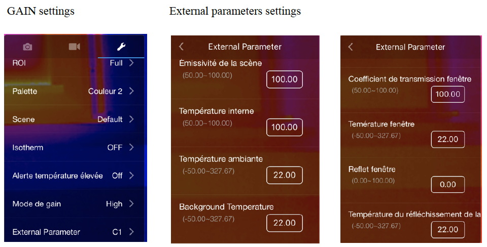
- Take off manually using DJI GO - Fly at the suited altitude - Point the camera in the nadir position - Tap for focus, manually - Close DJI GO and launch GSPro to upload the mission while the Drone is in the air | Open DJI GO first and set the following parameters: - Picture format shall be r-JPEG - Set the GAIN to HIGH - In ‘External Parameters’ set emissivity to 100% - In ‘External Parameters’ set the background and ambient temperature to 22 degrees - Close DJI GO and open and launch GSPro |
GSPro setup
Product Type | 3D Map Area |
Shooting Angle | Parallel to main path |
Capture Mode | Capture at Equal Time Interval |
Flight course mode | Scan Mode |
Resolution | See the Data Product Description in Chapter 6.2. of this document |
Front overlap | See the Data Product Description in Chapter 6.2. of this document |
Side overlap | See the Data Product Description in Chapter 6.2. of this document |
Gimbal pitch | - 90 (nadir) |
Course Angle | Use the Course Angle to align with the directions of the rows of the tables (parallel to the short sides) |
Margin | Adjust such that the flight path Is at least 2 flight lines outside the boundaries in all directions |