
Post-processed kinematic (PPK) and real-time kinematic (RTK) have been used in terrestrial surveying for years to improve the accuracy of Global Navigation Satellite System data. Both methods correct the location of drone mapping data and reduce (not eliminate) the need for GCPs, bringing the relative accuracy down to the centimeter range. However, in order to achieve centimeter precision in absolute accuracy when flying with RTK and PPK, greater care is needed to achieve this precision. Here we provide some guidelines to ensure you are able to submit the cleanest input for the SIDEREAL Fuse platform to process.
Data gathering options and required equipment
RTK - Known point
Relative positional data is sent real-time from the base station to the drone, which is synced to the base station. The equipment you will need for this is the following:
RTK enabled drone
Base station
Survey equipment to measure the placement point of the base station (if no known points are available to set the base station on).
RTK - Correction service provider
Utilising a correction service provider will allow your controller to communicate via cellular/wifi connection with the server of a correction provider and real-time corrections are sent from the server to the controller of the drone, applying the corrections directly to the images captured. The equipment you will need for this is the following:
RTK enabled drone
Subscription to a correction service provider (eg Trimble VRS, Leica SmartNet)
PPK
Raw satellite data is recorded at both the base station and the drone. The data is then post processed on a computer and applied to the photos after the flight. The equipment you will need is the following:
PPK enabled drone
Base station capable of logging satellite data
Survey equipment to measure placement point of the base station (if no known points are available)
Setting up your equipment
The first step in setting up will depend on which set up you have opted to go with, you can find your set up below and follow those instructions.
RTK (Base station)
For RTK (with a base station) the base station needs to be set-up on a known point in order to have absolute accuracy, meaning that you will need to set up the base station on an already known point or survey the point in yourself placing the base station on top of it and enter the coordinates into the controller. Make sure the coordinate system you are enter the position of the point in matches the point that the base station is using.
Linking your drone to the base station will depend on your drone, however you should make sure they are properly linked before your flight
Connect your controller to your drone
RTK (Correction service)
If you are using a correction service provider instead of a base station you will need to add a sim card to your RTK controller which you will need to connect to the internet and then the correction service provider. You will need continual internet connection for this method, if there is a drop in coverage you will not be able to collect any data.
Connect your controller to your drone
PPK
For RTK (with a base station) the base station needs to be set-up on a known point in order to have absolute accuracy, meaning that you will need to set up the base station on an already known point or survey the point in yourself placing the base station on top of it and enter the coordinates into the controller. Make sure the coordinate system you are enter the position of the point in matches the point that the base station is using.
Linking your drone to the base station will depend on your drone, however you should make sure they are properly linked before your flight
Connect your controller to your drone
Once you have conducted your flight you will need to process the base station data in order to calculate the coordinates of where the base station was setup relative to a geodetic coordinate system.
You will then need to upload the raw satellite data collected by both the base station and drone along with the images captured to your chosen third party software which will process your data and either amend the metadata of the images to reflect the corrected location coordinates, or create a CSV file with your post processed coordinate information.
Things to watch out for
If your base station is not properly positioned on a known point, you will have good relative accuracy between the photos, however you will not have good absolute accuracy relative to a coordinate system (eg WGS84)
All equipment should be running the latest firmware. Otherwise there could be issues with pairing the equipment before the flight and also in recording the data. If you update the firmware on your base station, you need to ensure to update the firmware on both your drone and your controller so you don't have any issues linking them.
If you are flying PPK, remember to tell your base station and the drone to log the raw data. If you fly PPK and do not log raw satellite data you will not be able to post process your data set.
Do I still need GCPs if I'm using RTK/PPK?
Yes, we would still advise to use three GCPs per flight whilst using RTK/PPK. These will act as checkpoints in order to verify the RTK/PPK obtained coordinates for the images are accurate. Ensure your GCPs are clearly marked!
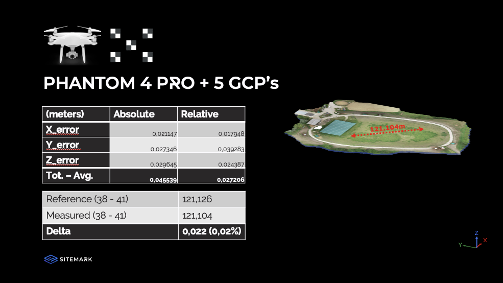
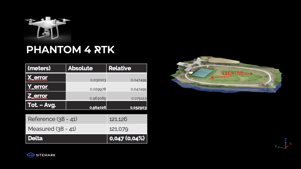
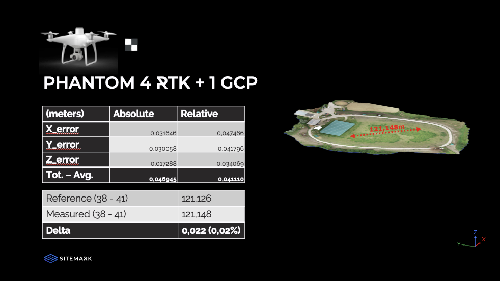
In the past we have conducted some tests to look into the different accuracies you can expect with certain set ups. Below you can find some of the results of the webinar so you can assess what set up you would require for your inspection needs.
More information on GCPs can be found here, and how to tag them in the platform here.